

What scientists know so far — and how ice, rock and a mountain river can combine to create a devastating flood.
 |
Image source: U.S. Geological Survey (USGS), Landsat 9 First Light Image of the Himalayas — Public Domain. |
Photo of the actual August 26, 2026 disaster: Current photographs from the affected area are available through the Associated Press photo gallery. The AP images are copyrighted, so they are linked here rather than embedded without a usage licence.
View the AP photo gallery of the 2026 Nepal floods
View the AP photo gallery of the 2026 Nepal floods
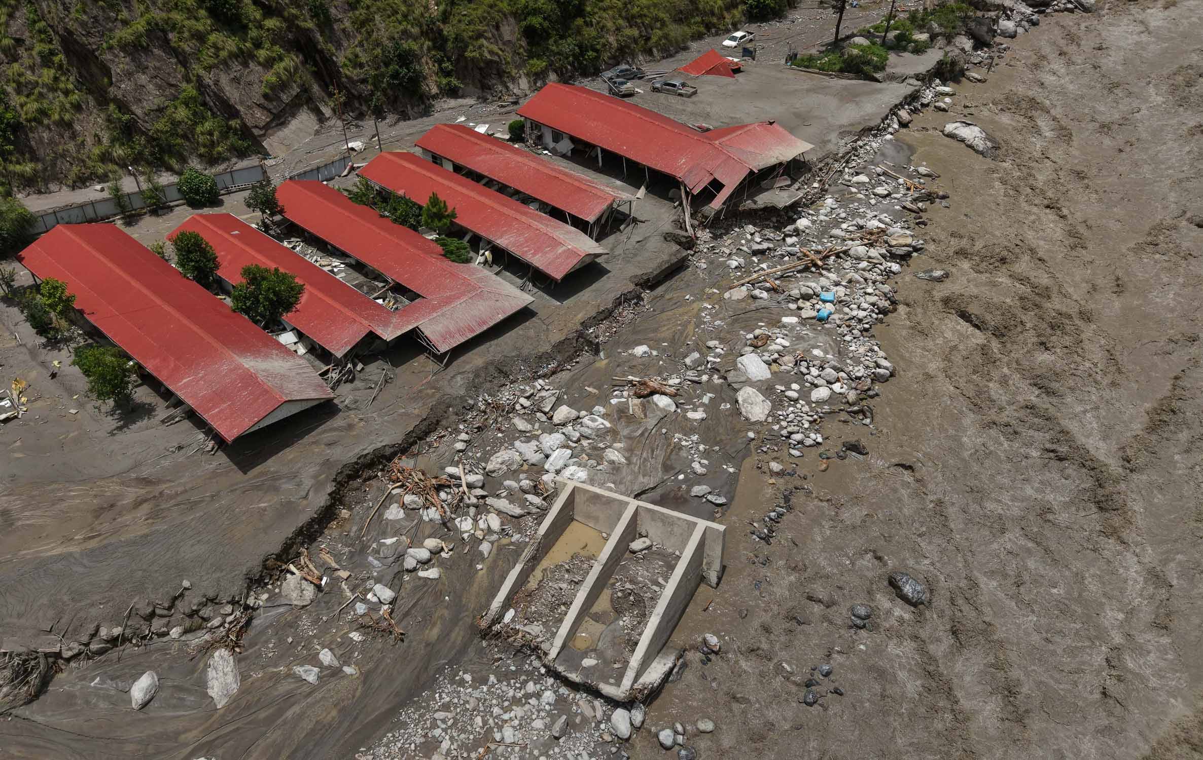
On August 26, 2026, a powerful flash flood swept through Nepal’s Rasuwa district near the border with China’s Tibet region. Homes, roads, bridges and hydropower infrastructure were damaged or destroyed, while rescue teams continued searching for missing people.
The most important scientific question, however, is not only what the flood destroyed. It is how a disturbance high in the Himalayas could turn into a destructive wall of water downstream.
What Happened in the Himalayas?
Satellite imagery reviewed by experts indicates that part of a glacier at roughly 5,200 metres above sea level broke away and fell about 1,200 metres into the valley. The falling ice appears to have entrained rock and sediment, producing a powerful ice-rock avalanche.
ICIMOD and other experts are investigating whether this material entered the Lhende Khola, a river connected to the Bhote Koshi and Trishuli systems. Preliminary assessments suggest that debris may have temporarily blocked the river, creating an unstable natural dam.
How Can an Ice-Rock Avalanche Cause a Flood?
A mountain collapse does not need to contain a huge volume of liquid water to produce a flood. The key is what happens when the debris reaches a river.
The resulting flood can be much more dangerous than ordinary river flooding because it may contain a heavy mixture of water, mud, gravel, ice and large boulders.
Why Did the Water Rise So Quickly?
Mountain valleys are often steep and narrow. When a large volume of water is suddenly released into such a confined channel, the flow can accelerate and remain concentrated rather than spreading across a wide floodplain.
ICIMOD reported that water levels on the Trishuli River at Galchchi reportedly rose by as much as nine metres within about 30 minutes. Such a rapid rise is consistent with a powerful flood wave moving through the river system.
Was an Earthquake the Trigger?
A magnitude 4.4 earthquake was recorded in Tibetan territory around the time of the disaster. Early reports considered whether the earthquake might have triggered the collapse.
However, scientists have not established a causal link. ICIMOD says unusual seismic signals were detected, but researchers are still examining whether those signals were connected to the suspected avalanche. The earthquake should therefore be described as a possible trigger under investigation, not as a confirmed cause.
What About Climate Change?
This is one of the most important questions, but it requires scientific caution. The Hindu Kush Himalaya is experiencing rapid changes in glaciers, snow, permafrost and mountain slopes. ICIMOD reported in 2026 that Himalayan glacier ice-loss rates have accelerated markedly compared with the beginning of the century.
Those changes can alter the background stability of high mountain environments. But that does not prove that climate change caused this particular flood. Event-specific attribution requires further analysis of the glacier, temperature, snow conditions, seismic activity and slope stability.

Why Are Himalayan Rivers So Vulnerable?
The Himalayas combine several hazards in one environment: very steep slopes, glaciers, snow, unstable rock, narrow valleys and powerful rivers. Because these systems are connected, one event can trigger another.
A glacier collapse can produce an avalanche. The avalanche can block a river. The blockage can form a temporary lake. If that lake suddenly drains, the resulting flood can carry sediment and boulders far downstream.
NASA has documented similar cascading processes in Nepal, including cases where landslides blocked rivers and created temporary natural dams that later posed a major flood hazard.
Why Satellite Images Matter
Some of the most important evidence in the Nepal disaster has come from satellite observations. High-altitude valleys can be difficult and dangerous to reach immediately after a disaster, while satellites can compare the landscape before and after an event.
In this case, before-and-after imagery helped researchers identify the apparent collapse of part of the glacier and the new deposits of debris and sediment in the valley.
What Does This Disaster Teach Us?
The biggest lesson is that mountain disasters rarely respect simple categories. A single event can move through several stages:
Understanding this chain is essential for early-warning systems and for communities living downstream from glaciers and steep mountain valleys.
Frequently Asked Questions
What caused the Nepal flash flood?
Preliminary evidence points to an ice-rock avalanche associated with a glacier collapse, followed by river blockage and a sudden downstream surge. The exact initiating mechanism remains under investigation.
Preliminary evidence points to an ice-rock avalanche associated with a glacier collapse, followed by river blockage and a sudden downstream surge. The exact initiating mechanism remains under investigation.
Was the flood caused by an earthquake?
A magnitude 4.4 earthquake occurred around the same time, but scientists have not yet established that it triggered the collapse.
A magnitude 4.4 earthquake occurred around the same time, but scientists have not yet established that it triggered the collapse.
What is an ice-rock avalanche?
It is a rapid downslope movement containing ice, rock, snow and debris. In steep terrain it can travel quickly and dramatically alter a river valley.
It is a rapid downslope movement containing ice, rock, snow and debris. In steep terrain it can travel quickly and dramatically alter a river valley.
Can a blocked river suddenly create a flood?
Yes. A debris blockage can act like a temporary natural dam. If water breaks through or overtops it, a sudden flood wave can travel downstream.
Yes. A debris blockage can act like a temporary natural dam. If water breaks through or overtops it, a sudden flood wave can travel downstream.
Did climate change cause this disaster?
It is too early to make that claim for this individual event. Climate change is altering Himalayan glaciers and high-mountain conditions, but its specific contribution to this collapse requires further scientific analysis.
It is too early to make that claim for this individual event. Climate change is altering Himalayan glaciers and high-mountain conditions, but its specific contribution to this collapse requires further scientific analysis.
The Bigger Picture
The Nepal disaster shows why the mountains should not be viewed as isolated peaks. Glaciers, slopes and rivers form one connected system. A sudden change high above a valley can become a life-threatening flood many kilometres downstream.
That is why scientists increasingly combine satellite imagery, seismic records, glacier monitoring and river observations when studying Himalayan hazards.
Scientific & Reliable Sources
ICIMOD — August 26, 2026: Preliminary scientific assessment of the Rasuwa flash flood, suspected ice-rock avalanche, river blockage, rapid water-level rise and continuing investigation.
ICIMOD: Major flash flood sweeps through Nepal’s Rasuwa district
Reuters — August 26, 2026: Satellite evidence indicating that part of a glacier broke away at around 5,200 metres and fell roughly 1,200 metres, producing an ice-rock avalanche.
Reuters: Glacier collapse may have triggered deadly Nepal flash flood
The Kathmandu Post — August 26, 2026: Preliminary assessment of a debris blockage about 20 km upstream of the Miteri Bridge and the possibility of a temporary debris lake.
Kathmandu Post: Ice avalanche, debris lake may have triggered Bhotekoshi flood
USGS: Satellite observations of the Himalayas and the role of Landsat in monitoring glaciers and glacial meltwater lakes. The image used above is Public Domain.
USGS: Landsat 9 First Light Image of the Himalayas
NASA Earth Observatory: Scientific background on how landslides and natural dams can contribute to sudden flooding in Nepal.
NASA Earth Observatory: Making Sense of Nepal’s Seti River Disaster
Image used for historical context: Rasuwa flood aftermath photograph from an earlier 2025 event, used only to illustrate the Himalayan valley environment and not to represent the August 2026 disaster.
Nepal Views: Aftermath of Rasuwa Flood
Editorial note: The August 2026 disaster is still under scientific investigation. This article intentionally separates confirmed observations from preliminary explanations. Update the article if ICIMOD, USGS, Nepalese authorities or other scientific institutions publish a revised assessment.
ICIMOD — August 26, 2026: Preliminary scientific assessment of the Rasuwa flash flood, suspected ice-rock avalanche, river blockage, rapid water-level rise and continuing investigation.
ICIMOD: Major flash flood sweeps through Nepal’s Rasuwa district
Reuters — August 26, 2026: Satellite evidence indicating that part of a glacier broke away at around 5,200 metres and fell roughly 1,200 metres, producing an ice-rock avalanche.
Reuters: Glacier collapse may have triggered deadly Nepal flash flood
The Kathmandu Post — August 26, 2026: Preliminary assessment of a debris blockage about 20 km upstream of the Miteri Bridge and the possibility of a temporary debris lake.
Kathmandu Post: Ice avalanche, debris lake may have triggered Bhotekoshi flood
USGS: Satellite observations of the Himalayas and the role of Landsat in monitoring glaciers and glacial meltwater lakes. The image used above is Public Domain.
USGS: Landsat 9 First Light Image of the Himalayas
NASA Earth Observatory: Scientific background on how landslides and natural dams can contribute to sudden flooding in Nepal.
NASA Earth Observatory: Making Sense of Nepal’s Seti River Disaster
Image used for historical context: Rasuwa flood aftermath photograph from an earlier 2025 event, used only to illustrate the Himalayan valley environment and not to represent the August 2026 disaster.
Nepal Views: Aftermath of Rasuwa Flood
Editorial note: The August 2026 disaster is still under scientific investigation. This article intentionally separates confirmed observations from preliminary explanations. Update the article if ICIMOD, USGS, Nepalese authorities or other scientific institutions publish a revised assessment.


0 Comments